John Anevski
Curious about Wooden Canoes
The Moose River Bow Trip near Jackman, Maine – Solo canoe trip
9:20 AM, September 13, 2010 to 11:30 AM, September 15, 2010
This is an abbreviated trip report due to the size of posts on this forum. The read the full report, please go to:
http://www.myccr.com/SectionForums/viewtopic.php?p=342445#p342445
OR
http://www.solotripping.com/community/showthread.php?t=3188
It rained, my canoe leaked, my boots leaked, my rain pants leak, my kitchen tarp leaked. Boy, I had a great time!!!! Temperature ranged from 45 degrees F at night and morning, up to 55 degrees F during the day. Mostly cloudy, but the sun peeked out during the day on the second day. At night, the sky cleared and the stars were bright. Each morning before I got up, it rained. It also rained each afternoon just as I was getting to camp, and of course off and on during the day.
My general philosophy for outdoor activities worked – do everything you can to keep yourself and your gear dry, but plan on being wet. Dry wool socks and shoes in camp at night feel great.
From when I left to when I got back to the starting point, I did not see anyone else. My canoe is a Richardson Aquacraft or Rilco 15 ½ foot wood and canvas. It weighs about 50 or so pounds, except on the portage where it gains an addition 50 pounds. It needs recanvasing, but I’m too busy canoeing, so it leaks a little. Along with my two paddles, I brought along my 12-foot lodgepole pine pole with a spike on one end. It was a nice break from paddling to be able to stand and use some different muscles at times.
September 13, 2010
Mile 0 - Launch at the end of Attean Rd. outside of Jackman, Maine.
Nice paddle across Attean Pond. Saw some loons who sang to me off and on. Was able to use my pole in some shallow areas. Wind was Southerly but it didn’t bother me too much. Nice camping areas along both ponds.
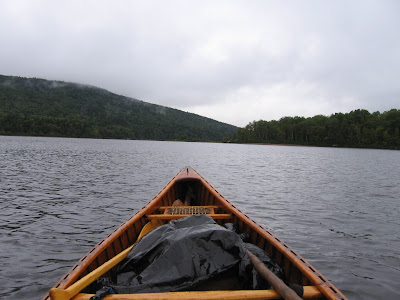
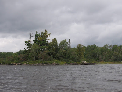
The cloudy and misty weather was with me most of the trip. The above picture is looking at the bay on the West end of Attean Pond. Once I was in that bay had a nice following wind. Also as I neared the shore got to do some surfing on small waves.
Mile 4.75 – On the West end of the Attean Pond, at the end of the bay is the portage.
The carry is 1.2 miles according to the sign. Of course, as you carry your stuff across, it seems like 50 miles all uphill. Note, when the planking is wet, some of it is very slippery as I found out. Took one slip with the canoe down to my knees. Not fun.
Mile 9.25 – I crossed Holeb Pond.
Mile 10.25 – Holeb Stream joins Moose River. The current was quicker on Moose River and the water clearer. The upper reaches of Moose River have some shallow areas and I was able to pole a lot. I think it was after Camel Rips or so, the River got pretty deep so unless I hugged a shore I wasn’t able to pole.
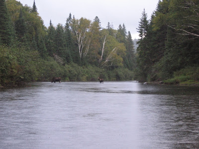
I camped at the first campsite on the Moose River (there are designated campsites where you have to camp) by Barrett Brook. Saw the only moose on the trip right at the camp – a cow and calf. She was eating and stayed awhile as I set up camp in the rain. Had a good night. When I got up at night, it had cleared. Stars everywhere. Of course, when I was getting up in the morning, it was pouring. I slept in my Hennessy Hammock. Comfortable and dry as always.
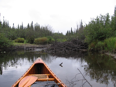
The next morning I went up Barrett Brook, nice poling Brook, but turned around after 5 beaver dams. Pole, stop, get out, haul canoe over, get in, pole, stop, get out, haul canoe over, get in, etc.
Beaver dam on Barrett Brook
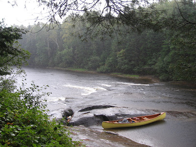
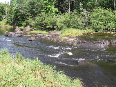
Mile 14 – Paddled and poled down to Camel Rips. This looked like a nice campsite. Where I camped was nice but this one seemed nicer.
Camel Rips from the campsite. The portage was just carrying the canoe and gear over the rocks. Not sure if you can tell, but it’s raining hard.
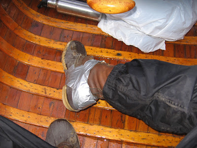
On the way to Holeb Falls is a little rip I tried to pole through (could have just paddled) and decided to see if my boots leaked. Lost my balance, put the gunnel in the water and my legs. That’s when I found out my boots leaked. As a matter of fact, the stitching from the rubber bottoms to leather tops had finally given out on the heels. Gosh, and I only had these L.L. Bean boots for 22 year, and have worn them a lot. Wrung out my socks and moved on.
The little rip where I slipped
Mile 18.5 – After a while, I was getting near the Holeb Falls Portage. The River branch to the left of the island above the falls, the on to take, had a beaver dam across it. Had to make a couple of small carries, one up and over a steep hill. Went through some areas with large boulder, some in the river, but was easily able to go around them.
Mile 19.75 – Paddled on to Mosquito Rips, a short drop. Nice campsites here also, but had to keep moving.
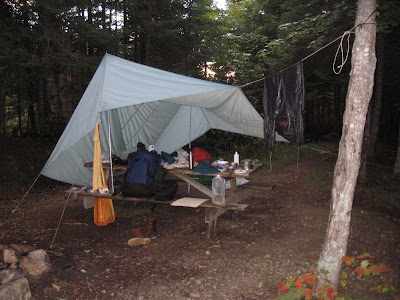
Mile 23.75 – Made it to Spencer Rips where I spent the night. Nice night. Again, clear night with many stars. When I woke up I was thinking it will be nice to put the tarp away drier then the day before. Then it started to rain again. Oh will, still having fun.
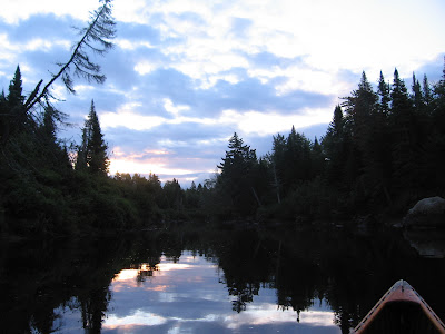
Breakfast and tea and then on my way. I was being picked up at Noon, so I had to get moving. Left at 6:30.
The leaky tarp (ok, just some of the seams leaked)
Early morning on the Moose
Paddling downstream was nice, except when the channel was heading North. Oh, oh, Northerly wind, how will it be on Attean Pond. Nice paddling, deep water. I generally kept track of where was by the monitoring the bends in the river, but could pinpoint whenever I reached a campsite (they had signs). When I didn’t see the campsite between Spencer Rips and Attean Falls, I started to become discouraged. Was I really paddling that slowly that I hadn’t even passed the campsite???? Finally I spotted a landing on the left side but no sign and then some rapids. I looked around for a way to carry around, but it was too rocky. I paddled through the rapids, they weren’t too bad, more shallow then fast. Scrapped a little here and there.
Mile 30.25 – Then finally, I saw the portage sign on the right and was at Attean Falls and the rapids I just passed was the upper carry. I took out at the campsite, but about 100 feet downstream is another takeout that shortens the walk.
Boot repair
Mile 31.75 – Made it to Attean Pond. Strong Northwest wind with 1 foot waves. It was shallow and weedy, so I tried poling but the bottom was too mucky. The pole kept sinking and sticking in the muck. Paddled to the lee of the islands where I could. Wind was gusty and it would blow me off course. Once it pushed me off course and to one of the shores. I poled up along the shore until I was able to head Northerly again. With the weight forward, I was able to paddle better into the wind. After getting around the smaller islands, I aimed for Birch Island. The waves were 1 to 2 feet at that time. The canoe handled the waves well, only some spray made it into the canoe. As I mentioned above, if it was much windier, I may not have been able to paddle against it.
When I neared Birch Island and could see the landing to the East, the waves calmed down. The fetch was small enough the wind and waves calmed some. I was able to head East to the landing. A little island on the way to the landing.
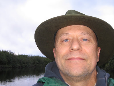
The Happy Paddler
Mile 34 –Got to the landing at 11:30 AM and my ride was waiting. Great trip.
The Maine Guide at the landing recommended Mamma Bear (I think that was the name) for good home cooking. It is the first restaurant on the left going North through Jackman. The burger and fries were great.
Various links about the trip:
http://bp2.trimbleoutdoors.com/ViewTrip/490573
http://www.maine.gov/cgi-bin/online/doc/parksearch/details.pl?park_id=55
http://canoewilds.com/wildtrips/trip_me_mooseriver.html
http://pennkayaker.com/wiki/guest.a... River Bow Loop Wilderness Canoe Camping Trip
9:20 AM, September 13, 2010 to 11:30 AM, September 15, 2010
This is an abbreviated trip report due to the size of posts on this forum. The read the full report, please go to:
http://www.myccr.com/SectionForums/viewtopic.php?p=342445#p342445
OR
http://www.solotripping.com/community/showthread.php?t=3188
It rained, my canoe leaked, my boots leaked, my rain pants leak, my kitchen tarp leaked. Boy, I had a great time!!!! Temperature ranged from 45 degrees F at night and morning, up to 55 degrees F during the day. Mostly cloudy, but the sun peeked out during the day on the second day. At night, the sky cleared and the stars were bright. Each morning before I got up, it rained. It also rained each afternoon just as I was getting to camp, and of course off and on during the day.
My general philosophy for outdoor activities worked – do everything you can to keep yourself and your gear dry, but plan on being wet. Dry wool socks and shoes in camp at night feel great.
From when I left to when I got back to the starting point, I did not see anyone else. My canoe is a Richardson Aquacraft or Rilco 15 ½ foot wood and canvas. It weighs about 50 or so pounds, except on the portage where it gains an addition 50 pounds. It needs recanvasing, but I’m too busy canoeing, so it leaks a little. Along with my two paddles, I brought along my 12-foot lodgepole pine pole with a spike on one end. It was a nice break from paddling to be able to stand and use some different muscles at times.
September 13, 2010
Mile 0 - Launch at the end of Attean Rd. outside of Jackman, Maine.
Nice paddle across Attean Pond. Saw some loons who sang to me off and on. Was able to use my pole in some shallow areas. Wind was Southerly but it didn’t bother me too much. Nice camping areas along both ponds.
The cloudy and misty weather was with me most of the trip. The above picture is looking at the bay on the West end of Attean Pond. Once I was in that bay had a nice following wind. Also as I neared the shore got to do some surfing on small waves.
Mile 4.75 – On the West end of the Attean Pond, at the end of the bay is the portage.
The carry is 1.2 miles according to the sign. Of course, as you carry your stuff across, it seems like 50 miles all uphill. Note, when the planking is wet, some of it is very slippery as I found out. Took one slip with the canoe down to my knees. Not fun.
Mile 9.25 – I crossed Holeb Pond.
Mile 10.25 – Holeb Stream joins Moose River. The current was quicker on Moose River and the water clearer. The upper reaches of Moose River have some shallow areas and I was able to pole a lot. I think it was after Camel Rips or so, the River got pretty deep so unless I hugged a shore I wasn’t able to pole.
I camped at the first campsite on the Moose River (there are designated campsites where you have to camp) by Barrett Brook. Saw the only moose on the trip right at the camp – a cow and calf. She was eating and stayed awhile as I set up camp in the rain. Had a good night. When I got up at night, it had cleared. Stars everywhere. Of course, when I was getting up in the morning, it was pouring. I slept in my Hennessy Hammock. Comfortable and dry as always.
The next morning I went up Barrett Brook, nice poling Brook, but turned around after 5 beaver dams. Pole, stop, get out, haul canoe over, get in, pole, stop, get out, haul canoe over, get in, etc.
Beaver dam on Barrett Brook
Mile 14 – Paddled and poled down to Camel Rips. This looked like a nice campsite. Where I camped was nice but this one seemed nicer.
Camel Rips from the campsite. The portage was just carrying the canoe and gear over the rocks. Not sure if you can tell, but it’s raining hard.
On the way to Holeb Falls is a little rip I tried to pole through (could have just paddled) and decided to see if my boots leaked. Lost my balance, put the gunnel in the water and my legs. That’s when I found out my boots leaked. As a matter of fact, the stitching from the rubber bottoms to leather tops had finally given out on the heels. Gosh, and I only had these L.L. Bean boots for 22 year, and have worn them a lot. Wrung out my socks and moved on.
The little rip where I slipped
Mile 18.5 – After a while, I was getting near the Holeb Falls Portage. The River branch to the left of the island above the falls, the on to take, had a beaver dam across it. Had to make a couple of small carries, one up and over a steep hill. Went through some areas with large boulder, some in the river, but was easily able to go around them.
Mile 19.75 – Paddled on to Mosquito Rips, a short drop. Nice campsites here also, but had to keep moving.
Mile 23.75 – Made it to Spencer Rips where I spent the night. Nice night. Again, clear night with many stars. When I woke up I was thinking it will be nice to put the tarp away drier then the day before. Then it started to rain again. Oh will, still having fun.
Breakfast and tea and then on my way. I was being picked up at Noon, so I had to get moving. Left at 6:30.
The leaky tarp (ok, just some of the seams leaked)
Early morning on the Moose
Paddling downstream was nice, except when the channel was heading North. Oh, oh, Northerly wind, how will it be on Attean Pond. Nice paddling, deep water. I generally kept track of where was by the monitoring the bends in the river, but could pinpoint whenever I reached a campsite (they had signs). When I didn’t see the campsite between Spencer Rips and Attean Falls, I started to become discouraged. Was I really paddling that slowly that I hadn’t even passed the campsite???? Finally I spotted a landing on the left side but no sign and then some rapids. I looked around for a way to carry around, but it was too rocky. I paddled through the rapids, they weren’t too bad, more shallow then fast. Scrapped a little here and there.
Mile 30.25 – Then finally, I saw the portage sign on the right and was at Attean Falls and the rapids I just passed was the upper carry. I took out at the campsite, but about 100 feet downstream is another takeout that shortens the walk.
Boot repair
Mile 31.75 – Made it to Attean Pond. Strong Northwest wind with 1 foot waves. It was shallow and weedy, so I tried poling but the bottom was too mucky. The pole kept sinking and sticking in the muck. Paddled to the lee of the islands where I could. Wind was gusty and it would blow me off course. Once it pushed me off course and to one of the shores. I poled up along the shore until I was able to head Northerly again. With the weight forward, I was able to paddle better into the wind. After getting around the smaller islands, I aimed for Birch Island. The waves were 1 to 2 feet at that time. The canoe handled the waves well, only some spray made it into the canoe. As I mentioned above, if it was much windier, I may not have been able to paddle against it.
When I neared Birch Island and could see the landing to the East, the waves calmed down. The fetch was small enough the wind and waves calmed some. I was able to head East to the landing. A little island on the way to the landing.
The Happy Paddler
Mile 34 –Got to the landing at 11:30 AM and my ride was waiting. Great trip.
The Maine Guide at the landing recommended Mamma Bear (I think that was the name) for good home cooking. It is the first restaurant on the left going North through Jackman. The burger and fries were great.
Various links about the trip:
http://bp2.trimbleoutdoors.com/ViewTrip/490573
http://www.maine.gov/cgi-bin/online/doc/parksearch/details.pl?park_id=55
http://canoewilds.com/wildtrips/trip_me_mooseriver.html
http://pennkayaker.com/wiki/guest.a... River Bow Loop Wilderness Canoe Camping Trip

