I have been given two Sanborn fire insurance maps of Old Town, Maine from December 1906 and October 1912 which have some very interesting information about the canoe companies there as shown below. More information about maps like this can be found at http://en.wikipedia.org/wiki/Sanborn_Maps if you are not familar with them.
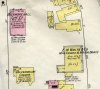
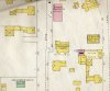
The first image is from the 1906 map and shows the "M'F'R Canvas Canoes" which was located on Shirley Street behind the hardware store. It had a "40 HP Eng." which ran on power from Jordan's Mill across town. This was where the first Indian Old Town Canoes were manufactured and apparently was still being used in 1906 even though they had expanded to the factory on Middle Street around 1901. This was adjacent to the "M'F'Y Ointment" building where the Bickmore Gall Cure was being manufacutured. The green colors were used for buildings that were designated as "Special" which presumably ment higher fire risks in this case.
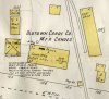
The second image is from 1906 and shows the "Oldtown Canoe Co." on Middle Street which was powered by a "25 HP Gas Eng." on the first floor. The first expansion building has been drawn in pencil along the "City Stable" and "Wood Shed" buildings. The image at http://forums.wcha.org/attachment.php?attachmentid=9793&d=1266775013 shows how this looked from the street.
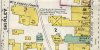
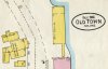
The third image is from 1906 and shows the E. M. White and Carleton Canoe companies. It is interesting to note that the White building was shown with a gray exterior which designated iron and was described as "IR.CL" (Iron Clad?) which appears to have avoided the "Special" green risk designation that was applied to the Carleton factory. The elevated risk rating appears to have been accurate since this Carleton building burned on May 17th, 1911. The red rectangle at the top shows that the Bickmore Gall Cure Company was building a new brick building in that location.
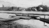
The fourth image is from 1906 and shows the Carleton canoe manufacturing and storage buildings that were adjacent to the river. The images at http://www.old-town.me.us/nos/pictures/p-20.jpg and http://forums.wcha.org/attachment.php?attachmentid=3706&d=1195677515 also show them. These buildings did not appear to have burned in 1911 since they are shown on the 1912 map but without any references to canoes.
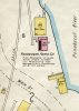
The fifth image is from 1906 and shows the "Indian Agency" which was adjacent to a "Canoe Store Ho." which may have been for canoes that were built by the Indians and sold through the store.
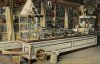
The sixth image is a postcard showing the inside of the "Indian Agency Store" with the things they had to sell including a small model bark canoe in the lower left corner.
Benson
The first image is from the 1906 map and shows the "M'F'R Canvas Canoes" which was located on Shirley Street behind the hardware store. It had a "40 HP Eng." which ran on power from Jordan's Mill across town. This was where the first Indian Old Town Canoes were manufactured and apparently was still being used in 1906 even though they had expanded to the factory on Middle Street around 1901. This was adjacent to the "M'F'Y Ointment" building where the Bickmore Gall Cure was being manufacutured. The green colors were used for buildings that were designated as "Special" which presumably ment higher fire risks in this case.
The second image is from 1906 and shows the "Oldtown Canoe Co." on Middle Street which was powered by a "25 HP Gas Eng." on the first floor. The first expansion building has been drawn in pencil along the "City Stable" and "Wood Shed" buildings. The image at http://forums.wcha.org/attachment.php?attachmentid=9793&d=1266775013 shows how this looked from the street.
The third image is from 1906 and shows the E. M. White and Carleton Canoe companies. It is interesting to note that the White building was shown with a gray exterior which designated iron and was described as "IR.CL" (Iron Clad?) which appears to have avoided the "Special" green risk designation that was applied to the Carleton factory. The elevated risk rating appears to have been accurate since this Carleton building burned on May 17th, 1911. The red rectangle at the top shows that the Bickmore Gall Cure Company was building a new brick building in that location.
The fourth image is from 1906 and shows the Carleton canoe manufacturing and storage buildings that were adjacent to the river. The images at http://www.old-town.me.us/nos/pictures/p-20.jpg and http://forums.wcha.org/attachment.php?attachmentid=3706&d=1195677515 also show them. These buildings did not appear to have burned in 1911 since they are shown on the 1912 map but without any references to canoes.
The fifth image is from 1906 and shows the "Indian Agency" which was adjacent to a "Canoe Store Ho." which may have been for canoes that were built by the Indians and sold through the store.
The sixth image is a postcard showing the inside of the "Indian Agency Store" with the things they had to sell including a small model bark canoe in the lower left corner.
Benson
Attachments
Last edited: