Old Town Ribs

pklonowski

Unrepentant Canoeist
In another thread, Benson says: "My next research project is to determine when Old Town switched from using straight ribs to tapered ones. This appears to be between 1914 and 1919 but I am still narrowing this down. Does anyone have a canoe in this range who can send some pictures and the serial number (at the risk of thread drift)? It is also interesting to note that the Indian Old Town canoe shown at http://forums.wcha.org/attachment.ph...0&d=1383597034 and described at http://forums.wcha.org/showthread.php?11487 has tapered ribs. This change may be another suggestion that came from J. R. Robertson. Another mystery,"

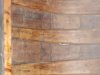
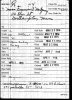
My OT HW #52727 has tapered ribs. The build started in November 1918, so this seems to be consistent with the theory... Let me know if you want dimensions.
 

Attachments

  • DSCF2042.jpg
    DSCF2042.jpg
    51.5 KB · Views: 370
Here is my 1914 Old Town Ideal. It has untapered ribs. It is an AA Grade Charles River, so I was thinking it was Old Town's attempt to be more Charles River like. I don't have a photo of the Serial No. handy.
 

Attachments

  • No Taper.jpg
    No Taper.jpg
    94.1 KB · Views: 355
  • BuildRecordIdeal.jpg
    BuildRecordIdeal.jpg
    130.7 KB · Views: 330
#8025, 1908 HW - Tapered ribsIMG_2887.jpgIMG_2854.jpg8025.jpg

Edit: I just looked at the 1908 catalog, which indicates "The ribs in the Charles River model have a uniform width of 2 inches. In the H.W. Model the ribs are 2 inches wide, tapering, as they leave the bottom, to 1 1/4 inches at the ends." This phrase remains in the catalog up through 1916.
In 1917 and onwards, the catalog reads "RIBS - of native Maine cedar, the toughest light weight wood obtainable, 5/16 inch thick, 2 inches wide spaced 1 1/2 inches apart. Ends tapered." This implies that all models had tapered ribs.
 
Last edited:
Well, I feel silly. This is all explained in the catalogs back to 1906. The 1916 catalog is the last one to mention the "uniform width" ribs in the Charles River Model. Thanks,

Benson
 
So it was only the Charles River model (and of course Ideal) that had full-width ribs? If so, it seems Fitz's conclusion is right-- they wanted the Charles River model to resemble a Charles River canoe. Interesting.
 
I've always believed that the Charles River model canoe was designed and named to compete for some of the market share that the Charles River-area builders were getting, and the Ideal was just icing on that cake. That Boston-area market was big during those years, it's just down the road from Maine, and one of the best known CR builders/marketers (Robertson) had recently been a employed at Old Town.
 
one of the best known CR builders/marketers (Robertson) had recently been a employed at Old Town.
It isn't clear exactly what Robertson's relationship was with Old Town in 1902 but he appears to have been more than just another employee. The organizational structure was changed, his name was added to the company name as shown at http://www.wcha.org/catalogs/robrt-ot/catalog.gif and http://www.wcha.org/catalogs/robrt-ot/factory.gif shows that it may have even been painted on the front of the factory. The Charles River model was originally identified in the catalogs as the Robertson model. All that changed in January of 1903 so the connection didn't last long.

Benson
 
Is that Katahdin from the West Branch/Abol stream??

It certainly looks like that area as shown at http://sggphoto.files.wordpress.com/2010/10/katahdin-from-abol-bridge-100310-1-blog.jpg and http://runtrails.net/journal/images/12_me/final.jpg but the period postcard attached below indicates that it was claimed to be from the Old Town area. The period picture at http://digitalmaine.com/avery/316/ seems to confirm that it was actually from the mouth of Abol Stream.

Benson
 

Attachments

  • Katahdin-OT.jpg
    Katahdin-OT.jpg
    181.9 KB · Views: 360
Last edited:
It isn't clear exactly what Robertson's relationship was with Old Town ... his name was added to the company name

Yes, that's exactly what I was referring to - of course he wasn't a regular workaday employee! Perhaps I should have put "employed" in quotes, but assumed most people here knew of Robertson's complex travels through the boatbuilding world of his day, and that his name was ahead of "Old Town" for a little while.

It always seemed to me a strange thing that the Robertson model was changed to the Charles River model. I get the feeling that the relationship between Old Town and Robertson may have been a troubled one (this is a supposition based on his short apparent tenure there and the name change of the Robertson model canoe), so even though Old Town might have been courting the Charles River market, one might think they wouldn't want to give a nod to Robertson in any way including to his operation on the Charles. But then again, if the relationship wasn't the best, maybe naming the "Robertson" model's name to "Charles River" might have been a good jab.
 
More hi-jack

It certainly looks like that area as shown at http://sggphoto.files.wordpress.com/2010/10/katahdin-from-abol-bridge-100310-1-blog.jpg and http://runtrails.net/journal/images/12_me/final.jpg but the period postcard attached below indicates that it could be from the Old Town area. I have some ideas where this might have been taken but haven't been out to confirm them yet.

Benson

The Knife Edge is about 70 miles away from Old Town as the crow flies. Is that really possible? The image of Katahdin in that card looks much closer.
 
The image of Katahdin in that card looks much closer.

Katahdin is clearly visible from several points in the area (including interstate 95 just before the southern Old Town exit). However, the mountain seems unusually large in that old postcard image so they may have been using a telephoto lens (or simply not telling the truth about the actual location). It is too bad that cameras of that era didn't include any geotagging features.

Benson
 
I may have found an answer to the question about the location of this image in a letter from Louise Gray to her older brother Sam Gray that was postmarked November 5th, 1900 as shown below. She said "Uncle Herbert, George Richardson, Edith, Helen, and myself went out to Kukunsook Sat. and had some pictures taken in one of the new firm's canoes, do you know about it, so they can advertise them." I had always been told that Herbert was the person in the stern but never knew who the other two might have been.

Kukunsook is on the Old Town side of Pushaw Lake as described at http://genforum.genealogy.com/me/messages/15349.html and on page 34 of Indian Place Names of the Penobscot Valley and the Maine Coast by Fannie H. Eckstorm which identifies Kukunsook as "'cedars' Moses Greenleaf's name for Pushaw" in the section describing the lake.

Sam was just starting his sophomore year in college at that time and his younger sister Louise was still at home in high school. Their father George had probably partnered recently with his brother Herbert and their friend George Richardson to start the Indian Old Town Canoe Company but no known records are available to confirm this. George and Herbert's other brother Wilbur had a daughter named Edith and Herbert's daughter was named Helen.

The picture was used on the catalog covers of the Indian Old Town Canoe Company as shown at http://www.wcha.org/catalogs/indin-ot/catalog.gif in 1901, the Robertson and Old Town Canoe Company at http://www.wcha.org/catalogs/robrt-ot/catalog.gif in 1902, and the Old Town Canoe Company at http://www.wcha.org/catalogs/old-town/covers/large-04.gif in 1904.

The letters described at http://forums.wcha.org/showthread.php?9315 appear to have solved this small mystery.

Benson
 

Attachments

  • IOTC-pictutres-2.jpg
    IOTC-pictutres-2.jpg
    208.5 KB · Views: 322
  • IOTC-letterhead.jpg
    IOTC-letterhead.jpg
    205.1 KB · Views: 312
  • IOTC-pictutres-1.jpg
    IOTC-pictutres-1.jpg
    293.4 KB · Views: 314
Last edited:
Oh how fun to have more information on this picture! Maybe they wanted ladies in the canoe so it would appear to be a "safe" thing to do.
 
My earlier claim of having found the location of this image needs to be retracted. I went to Kukunsook on Pushaw Lake yesterday and could not see Katahdin nor find a shore line that looked like the one in this picture. My best efforts are shown below. A brief conversation with a long time resident of the area confirmed that Katahdin is not visible from the lake. My current guess is that the letter may be referencing the picture shown at http://www.wcha.org/catalogs/old-town/covers/large-03.gif from the 1903 catalog. These ladies are clearly trying to make canoeing appear safe as Kathy mentioned.

Benson
 

Attachments

  • Pushaw-1.jpg
    Pushaw-1.jpg
    152.7 KB · Views: 309
  • Pushaw-2.jpg
    Pushaw-2.jpg
    182.6 KB · Views: 321
Last edited:
I recently stumbled across the image at http://digitalmaine.com/avery/316/ in the Maine State Archives which may affirmatively answer Mike's question from 12-11-2013. This picture from September, 1899 appears to show the same background and profile of Katahdin as shown on some of the earliest Old Town Canoe Company catalog covers.

Benson
 
Back
Top